CCTV Systems See our features
01.
Sed nibh sapien, auctor nec eleifend in, mattis non purus. Aliquam bibendum tempor ligula, id suscipit justo euismod quis.
02.
Nullam eget arcu et erat sollicitudin suscipit eu eget nisl. Fusce id mauris consequat, eleifend erat nec, rutrum orci. Aliquam erat volutpat.
03.
Sed nibh sapien, auctor nec eleifend in, mattis non purus. Aliquam bibendum tempor ligula, id suscipit justo euismod quis.
04.
Nullam eget arcu et erat sollicitudin suscipit eu eget nisl. Fusce id mauris consequat, eleifend erat nec, rutrum orci. Aliquam erat volutpat.
Objects protected
Years of experience
Professionals
Cameras Installed
Ensure the peace of
your family and home
Vestibulum commodo at dolor eu aliquam. In congue ornare augue eu scelerisque. Duis vestibulum, dolor sed facilisis laoreet.
Our Team
Pellentesque mattis mauris ac tortor volutpat, eu fermentum sapien euismod. In id tempus metus. Donec eu volutpat nibh, in maximus ligula.
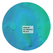
สร้างปริมาตร
การคำนวณปริมาตรกองหินภายในพื้นที่สำรวจเกี่ยวข้องกับการสำรวจภาคสนามร่วมกับการคำนวณทางคณิตศาสตร์ เพื่อกำหนดปริมาตรได้อย่างแม่นยำ จำเป็นต้องวัดรูปร่างของกองหินและคำนวณปริมาตรของมันให้ถูกต้อง
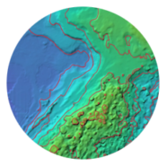
สร้างเส้นชั้นความสูง
เส้นชั้นความสูงคือเส้นบนแผนที่ที่เชื่อมต่อจุดที่มีระดับความสูงเท่ากัน ช่วยให้สามารถแสดงลักษณะภูมิประเทศและความสูงต่ำของพื้นที่ได้อย่างชัดเจนในรูปแบบภาพกราฟิก
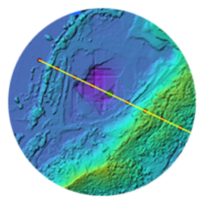
สร้างโปรไฟล์ความสูง
โปรไฟล์ความสูง หรือที่รู้จักกันในชื่อโปรไฟล์ภูมิประเทศหรือภาพตัดขวาง เป็นเครื่องมือที่มีประโยชน์สำหรับการแสดงภาพและวิเคราะห์การเปลี่ยนแปลงความสูงตลอดเส้นทางหรือเส้นที่กำหนดภายในพื้นที่สำรวจ