Best graduates of our classes are famous photographers all over the world
In nibh ante, aliquam sit amet molestie nec, tristique nec ligula. Integer sollicitudin nisl magna, a vulputate lectus ultricies fringilla. Integer quis ex massa. Ut laoreet quis magna vitae scelerisque. In pellentesque vel sapien ac iaculis. Praesent vestibulum purus ut facilisis sodales.
What will you learn in our photoschool?
- Camera Settings
- Exposure settings
- Depth of field
- Composition rules
- Lighting in photography
- Portrait photography
- Retouch
interesting classes
years of experience
professional teachers
happy customers
famous photographers
photography awards
Courses Recent classes
Have no time?
Try our Skype-classes!
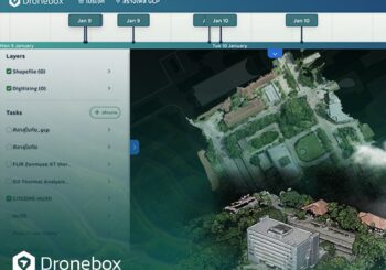
Our specialists will teach you the correct tuning, high-quality control and stunning shooting from the drones.
In nibh ante, aliquam sit amet molestie nec, tristique nec ligula. Integer sollicitudin nisl magna, a vulputate lectus ultricies fringilla. Integer quis ex massa. Ut laoreet quis magna vitae scelerisque. In pellentesque vel sapien ac iaculis. Praesent vestibulum purus ut facilisis sodales.

Our team Meet our teachers
Pellentesque mattis mauris ac tortor volutpat, eu fermentum sapien euismod. In id tempus metus. Donec eu volutpat nibh, in maximus ligula.
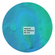
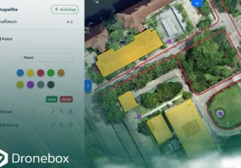
สร้างปริมาตร
การคำนวณปริมาตรกองหินภายในพื้นที่สำรวจเกี่ยวข้องกับการสำรวจภาคสนามร่วมกับการคำนวณทางคณิตศาสตร์ เพื่อกำหนดปริมาตรได้อย่างแม่นยำ จำเป็นต้องวัดรูปร่างของกองหินและคำนวณปริมาตรของมันให้ถูกต้อง
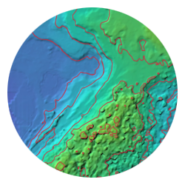
สร้างเส้นชั้นความสูง
เส้นชั้นความสูงคือเส้นบนแผนที่ที่เชื่อมต่อจุดที่มีระดับความสูงเท่ากัน ช่วยให้สามารถแสดงลักษณะภูมิประเทศและความสูงต่ำของพื้นที่ได้อย่างชัดเจนในรูปแบบภาพกราฟิก
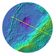
สร้างโปรไฟล์ความสูง
โปรไฟล์ความสูง หรือที่รู้จักกันในชื่อโปรไฟล์ภูมิประเทศหรือภาพตัดขวาง เป็นเครื่องมือที่มีประโยชน์สำหรับการแสดงภาพและวิเคราะห์การเปลี่ยนแปลงความสูงตลอดเส้นทางหรือเส้นที่กำหนดภายในพื้นที่สำรวจ
It's interesting Recent blog posts
- 14 May 2018
- 0
การเพิ่มชั้นข้อมูล GIS Shapefile และ GeoJSON เพื่อซ้อนทับกับข้อมูลแผนที่ใน Dronebox

- 14 May 2018
- 0